Meteodisplej
Úvodná stránka
Počasie Bratislava
Meteoradar
Dažďový radar
Teplotný radar
Veterný radar
Bleskradar
Správy o počasí
Zaujímavosti
Sprievodca aplikáciou
Widget počasie
Kontakt
Aplikácie
    Úvodná stránka / Zaujímavosti o počasí /

    Florida soaked! Tornado risk increases overnight.

23:49
16. decembra 2023

Florida soaked!
Tornado risk increases overnight

It’s been a soggy day, and the weather will get more active overnight with the chance for tornadic storms expanding from Jacksonville to Tampa to Miami.

Showers covered the entire state of Florida on Saturday, and it is about to get more active as the center of the low-pressure system moves inland, dissecting the state and a line of storms will sweep over the Peninsula. The severe storm risk will increase tonight, with the chance for tornadoes to develop.

Saturday's severe storm threat over Florida includes flooding, damaging winds and tornadoes, lasting through early Sunday morning.
Saturday's severe storm threat over Florida includes flooding, damaging winds, and tornadoes, lasting through early Sunday morning.

Some areas in South Florida, from midnight through 5 p.m., local time Saturday, have received over 1.5 inches of rain. Southwest Florida through Tampa has received between 0.5 to 1 inch, while Central Florida has received 0.75 to 1.5 inches of rain. North Florida has been the region with the least rainfall received, but this will change as heavier storms are forecast to arrive tonight.

Downpours will continue to affect most of Florida at least through Sunday afternoon. Residents should hunker down Saturday evening through early Sunday morning as there will likely be some strong to severe storms moving through the state, mainly from west to east.

Some of these severe storms could develop damaging winds of at least 60 mph and tornadoes. Flood advisories and warnings are in effect, mainly across coastal areas and counties. Low-lying areas are most prone to flooding and those areas, like South Florida, where showers have been falling since Wednesday.

It is impossible to know if and where a tornado will develop. What we know is that conditions are favorable for tornadoes. Please make sure to have at least 3 ways of receiving weather alerts tonight. Remember that nighttime tornadoes are twice as deadly as daytime ones.

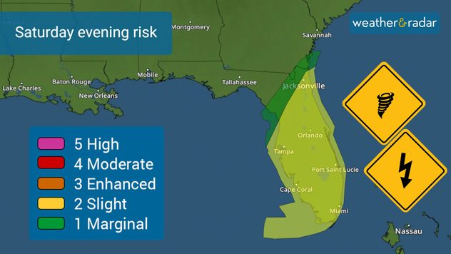
What does a tornado warning mean?

A tornado warning means that a tornado has been detected, by radar or visually, and you should go to a safe location at your home or work.

The storm will bring messy weather along the East Coast.

Once the storm crosses Florida and advances over the Carolinas and the Mid-Atlantic states, the system is expected to move quickly. However, there are still several hazards forecast. Precipitation could also be high, causing flash flooding. For now, the forecast indicates that rainfall could reach close to 5 inches and over 6 inches in some isolated areas. The coast of South and North Carolina and Virginia will deal with beach erosion, coastal flooding, and some areas with storm surge as the winds will be strong blowing onshore.

Weather will rapidly deteriorate over much of the Northeast on Sunday. Heavier downpours overnight through Monday morning are forecast across New York City through Boston. We do not forecast severe storms to move through the Northeast, but some spots could be dealing with flooding, especially those areas with poor drainage.

We are monitoring the weather overnight and will continue to bring you updates. If you can safely take pictures of flooding or damage that your area might have, please share them with us using our uploader or via social media, tag us!

**This information, written by our meteorologists, is also available in Spanish using our app in this language or in tiempoyradar.com

Irene Sans
Viac k téme
V Alpách napadal čerstvý sneh. Júnový návrat zimy. . . sobota 6. júna 2026
Mapa Álp so snežením vo vyšších polohách a fotografia zasneženej horskej stanice v hmle
sobota 6. júna 2026

Júnový návrat zimy

V Alpách napadal čerstvý sneh
Jún - sucho, búrky aj slnovrat. Prvý letný mesiac. . . streda 3. júna 2026
Rozkvitnutý horský lúčny kvet v zelenej krajine pod jasnou modrou oblohou, symbolizujúci začiatok júna
streda 3. júna 2026

Prvý letný mesiac

Jún - sucho, búrky aj slnovrat
Kde v Európe je už počasie na kúpanie?. Leto na blízku. . . streda 20. mája 2026
Mapa zobrazuje aktuálne teploty vody v Európe a Stredozemnom mori. Voda je obzvlášť teplá pri pobreží Španielska a severnej Afriky, chladnejšia v Severnom a Baltskom mori.
streda 20. mája 2026

Leto na blízku

Kde v Európe je už počasie na kúpanie?
Všetky správy o počasí
Mohlo by vás tiež zaujímať
UV index stúpa už poriadne vysoko. Nepodceňte slnko. . . sobota 23. mája 2026
Mapa Európy s vysokým UV indexom nad južnou Európou a Stredomorím
sobota 23. mája 2026

Nepodceňte slnko

UV index stúpa už poriadne vysoko
Nádherná polárna žiara na Slovensku. Galéria vašich fotiek. . . streda 21. januára 2026
Polárna žiara z dedinky Zaľubica na Spiši.
streda 21. januára 2026

Galéria vašich fotiek

Nádherná polárna žiara na Slovensku
Tučná porcia snehu na Vianoce 2023. Spomienky trvajú. . . piatok 26. decembra 2025
Ivan Veládi - Nitra (časť Klokočina)
piatok 26. decembra 2025

Spomienky trvajú

Tučná porcia snehu na Vianoce 2023
Všetky príspevky
Počasie & Radar

Počasie & Radar je k dispozícii aj na

Google Play StoreApp Store

O nás

Kontakt Ochrana údajov Impressum Vyhlásenie o prístupnosti

Naše služby

Uploader fotografií

Sociálne siete

facebookinstagramthreads